|
Working
Party Matters
Membership
| Terms of
Reference |
Task
Allocation |
Intranet
|
Geohazard Communication |
Links |
|
|
Landslides & Slope
Instability
Engineering Geologists | Planners & Developers | Finance & Insurance
| Member of the Public
|
|
Subsidence & Collapse
Hazard
Engineering Geologists | Planners & Developers | Finance & Insurance
| Member of the Public
|
|
Seismic Hazard
Engineering Geologists | Planners & Developers | Finance & Insurance
| Member of the Public
|
|
Flood Hazard
Engineering Geologists |
Planners & Developers | Finance & Insurance | Member of the Public
|
|
Tsunami Hazard
Engineering Geologists |
Planners & Developers | Finance & Insurance | Member of the Public
|
|
Volcanic Hazard
Engineering Geologists | Planners & Developers | Finance & Insurance
| Member of the Public
|
|
Gas Hazard
Engineering Geologists |
Planners & Developers | Finance & Insurance | Member of the Public
|
|
Fault Reactivation Hazard
Engineering Geologists | Planners & Developers | Finance & Insurance
| Member of the Public |
| |
|
Volcanic
Geohazard: Diagnostic Characteristics |
Index |
Diagnostic Characteristics
|
Geographic Occurrence |
Investigation & Mitigation |
Key Contacts & Expert Advice |
Photo
Gallery |
Essential References &
Further Reading | Definitions &
Glossary |
Structure of volcanoes
The structure of a volcano depends largely on
the engineering properties of the rocks have been erupted, the central conduit
(feeder channel. The central feeder channel may be a central vent or a fissure,
but it is the viscosity of the magma will determine the type of eruption. Acid
magmas are more viscous than basic magmas because they are richer in silica.
Gases can not escape as efficiently from acid magmas and so these tend to be
associated with more violent, explosive events and the volcanoes they give rise
to tend to be made more of pyroclastic deposits. By comparison, the more fluid
basic lavas give generate volcanoes that are constructed of layers of lavas that
represent successive eruptions. Volcanoes that are built from pyroclastic
deposits tend to grown much higher than those consisting predominantly of lavas.
Single vent eruptions (monogenetic) are therefore smaller and have a less
complex form compared to multiple vent (polygenetic) eruptions.
A lava dome is a mass of rock that has been
formed when viscous lava is extruded from a volcanic vent. The lava is too
viscous to flow more than a few tend to hundreds of metres form the vent before
it solidifies. Lava domes may occur along fissures, on the summit of volcanoes
or on their flanks. As the lava domes grow, their sides become unstable and they
are subject to failure by landsliding or collapsing. These may sometimes
associated with explosive events caused by the sudden release of gas. When these
process occur a lava domes builds up, usually no more than a few hundreds of
metres high, although these may be generated within a relatively small time
frame of less than one year.
When viscous magma is explosively erupted
this forms pyroclastic volcanoes. These tend to be much smaller than shield and
composite volcanoes, reaching several hundreds of metres high. These tend to be
located on the flanks of larger volcanoes, as parasitic cones and often they may
consist entirely of cinder cones and pumice cones.
Some volcanoes only emit gas, often during
the initial stages of an eruption. The explosive forces of the rapidly escaping
gas may be sufficient to generate an explosion vent. These types of volcano are
small in size and are composed of angular pyroclastic rocks, with a high
proportion of country rock, which surrounds the volcano. The vents may be
brecciated and filled with mixed, angular rocks.
Composite and strato-volcanoes are produced
from multiple eruptions volcanoes are the most common types and consist of
alternating layers of lava flows and pyroclasts. The basic, classic type of
strato-volcano is cone shaped, with concave slopes and a summit crater from
where the eruptions take place. As the volcano grows in height and evolves,
radial fissure and parasitic eruptions may occur on the flanks and cinder cones
may be scattered on the volcano slopes. The eruptive vents may migrate and
therefore some volcanoes have two or more central craters. Violent explosions
may also bring about changes to the structure and form of a volcano by blowing
away part of the volcano.
When the uppermost part of the magma chamber
has been depleted, following a major eruption, the volcanic structure may
collapse generating a huge summit crater. In extreme cases, the collapse of the
superstructure of a volcano into the magma chamber generates a caldera that may
reach several kilometres in diameter. Volcanic landforms may also be influenced
by other geological and geomorphological processes such as landslides and
mudflows.
Flood basalts describe the extensive
eruptions of basaltic lava flows that cover areas extending hundreds of
thousands of square kilometres (Tyrell 1937). For example, the lava flows which
form the Antrim Plateau in Northern Ireland are at least 130,000km2.
The Deccan and plateau in India extends over 640,000 km2 and at
Bombay reaches a thickness of approximately 3000m. The individual flows are
relatively thin, between 1 and 13 m in thickness. There are relatively few
pyroclastic deposits. Red-brown, oxidised weathered material on the upper part
of the lavas suggests that they were erupted intermittently. They appear to have
been erupted from both fissure and central vent type eruptions, and occur
throughout the world.
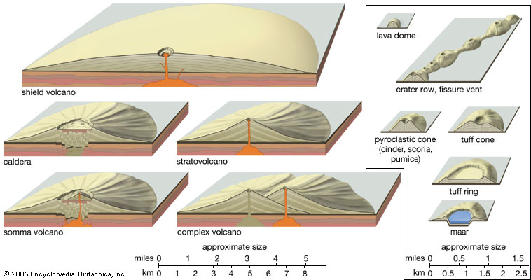
Profiles of volcanic landforms The
landforms shown at left and right are vertically exaggerated, and those shown at
right are out of scale to those shown at left. In reality a cinder cone would be
approximately one-tenth the size of a stratovolcano.(Image Source:
Encyclopædia Britannica, Inc.http://www.britannica.com/EBchecked/topic-art/632078/3256/The-major-types-of-volcanic-eruptions
)
Types of volcanoes
There are several different types of
volcanoes, as follows:
The major types of
volcanic eruptions. (Image Source: Encyclopædia Britannica, Inc.http://www.britannica.com/EBchecked/topic-art/632078/3256/The-major-types-of-volcanic-eruptions
)
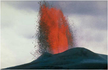
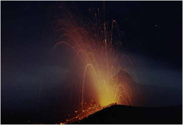
Hawaiian (Shield)
Hawaiian type eruptions are characterised by
quiet emissions of lava, due to their low viscosity (silica content) which
allows the escape of gas. This allows the relatively fast flow of lava which can
reach velocities of at least 50 kmh-1. Lavas may be erupted from a
summit crater or from fissures of the flanks of the volcano. Mauna Loa on the
island of Hawaii typifies this type of eruption and other examples can be found
on Iceland.
(Image Source:
Strombolian
If the lavas are more viscous and gases can
not readily escape, moderate explosions can occur. Lava is ejected into the air
to form cinders and bombs, and therefore pyroclasts accompany the extrusion of
lava. The ejected lavas and molten rocks fall close to the event and congeal in,
or around the vent. During the next eruption, gases may escape through these
deposits and throw blocks into the air. Steam and gases emitted often form
clouds that may linger above the summit crater. The volcanic activity of the
island of Stromboli, which is located on the Ionian Sea, north of Sicily and
west of Italy, typifies this type of eruption. This type of eruption occurs
consistently and at regular intervals throughout recent history.
(Image Source:
Vulcanian
The island of Vulcan, which also located in
the Ionian Sea, gives its name to ‘volcanoes’ and the vulcanian type of central
eruption. The lava is more viscous than the Strombolian type and therefore after
an eruption the magma in the conduit quickly solidifies. Gases subsequently
accumulate beneath the solidified lava that obstructs the vent until they reach
a pressure that exceeds the strength of the obstructing lava. This results in an
explosion, with fragments of lava and gas blown into the air. The lavas erupted
breach the sides of the central vent, and flow for some distance before they
congeal, and the process continues again.
(Image Source:
Vesuvian
The Vesuvian type of eruption is more violent
than the Strombolian and Vulcanian type. The central conduit becomes sealed with
a solidified plug of viscous lava allowing the build of considerable gas
pressures beneath it. Lava may then begin to escape through routes of less
resistance within the rock mass that forms the flanks of the volcano. As a
result, lava erupts on the flanks of the volcano through fissures or parasitic
vents on the middle and upper slopes. During these types of events the conduit
may be emptied to a considerable depth. The release of pressure allows dissolved
gases held in solution in the remaining magma to escape. This occurs with
enormous force, therefore clearing the conduit of any solidified, obstructions
of lava. This subsequently generates an explosion plume that travel high into
the atmosphere. Vesuvian type eruptions are followed by periods of long
quiescence. For instance, since the eruption of Vesuvius, Italy, in AD 79.
Plinian
A Vesuvian type eruption may increase in
violence into a Plinian type. The eruption of Vesuvius and the destruction of
the Pompeii and Herculaneum, near Naples, Italy, in AD 79, was a Plinian type of
eruption. The last Plinian type eruption on Vesuvius occurred in 1944. The
Plinian eruption itself lasted for only a few hours, but it was preceded by nine
days of Vesuvian type activity. This type of activity is characterised by lava
fountains that reach heights of 1 km and the violent explosion of gas sending an
eruption cloud to heights of at least 12 km, where they disperse, level out and
form a canopy (Carey and Sigurdsson 1989).
(Image Source:
Peléan
The Peléan type of central eruption is
associated with extremely viscous magma which results in catastrophic
explosions. Once again, the central conduit becomes clocked with viscous lava,
allowing the build up of magma with highly charged gas pressures. When the gas
pressure exceeds the strength of the volcano’s flanks the lava is violently
extruded, by the expanding gas, through fissures. A cloud of superheated hot gas
and ash is formed, called pyroclastic flows (known also as nuee ardentes).
These travel along the sides of the volcano with tremendous velocity, destroying
everything in its path. Before the eruption of Mount Pele, on the island on
Martinique, West Indies, in 1902 this type of volcanic activity had been
unknown.
Volcanic products and hazards
Volcanic eruptions generate a variety of
products that influence the terrestrial and marine environments and affect
people and infrastrcure in different ways. The affects will depend on, for
example, the type, magnitude, location and duration of the eruption. The most
common products and hazards are outlined below:
Lava flows
Lava flows are streams of molten rock that
pour from an eruption vent at temperatures only just above their freezing point
(MacDonald 1972). Lava may accompany explosive eruptions, forming lava fountains
or non-explosive activity. Lava, once erupted, flows within laminar streams as
it travels away from the eruptive vent or fissures, or along the flanks of a
volcano. Lava continues to flow until it solidifies at a temperature of between
600 and 900oC, although this will depend on the chemical composition
of the lava, its viscosity and gas content. The velocity of a lava flow is
highly variable and is controlled by the gradient and topography of the slope
down which it is moving, its consistency (composition, temperature, viscosity
and volatile content). Lava therefore flows faster nearer to its eruptive centre
and its velocities progressively decreases until it solidifies. Lava with higher
silica content will flow slower than basic lavas; the former may travel at
speeds of between 30 and 100 km h-1. Basaltic lavas may travel at
least 50 km from the eruptive centre before they congeal and solidify, whereas
andesitic flows rarely travel more than 8 km from their vents. Dacite and
rhyolite lavas rarely form flows, but instead generate lava domes.
Lava flows consist of numerous individual
lava units, each representing a single eruption event. Hummocky, fragmented,
splintery surfaces develop on the upper parts of recently deposited lava flows,
where they have congealed in contact with the cooler atmosphere. It is this
surface texture that allows basaltic lava to be categorised into ‘aa’ or
‘pahoehoe’ types. By comparison the central part may be characterised by
polygonal columnar jointing.
Lava flows are the main hazards at basaltic
volcanoes. Lava flows are rarely life threatening and deaths caused by lava
flows are rare. This is because their directions of flow may be pre-determined
and their relative low velocities, ranging from a few kilometres to several tens
of kilometres per hour, mean that they can be avoided by people. Deaths caused
by lava flows have been attributed to spectators and onlookers approaching an
advancing flow, explosions when lava interacts with water, the collapse of a
lava delta, asphyxiation due to associated toxic gases, lahars from glacier melt
water and pyroclastic flows from lava domes. Infrastructure, houses and
buildings will be almost always destroyed by an advancing lava flow. Land
affected by lava will, in most cases, not be possible to rehabilitate.
Larger lava flows may be fed by complex lava
streams and these may continue to flow beneath a solidified lava crust. However,
when the lava supply has been exhausted the stream of lava may drain out of the
tunnel through which it has been flowing to leave a lava tube. As these are
susceptible to collapse they pose a subsidence hazard.

Cross-section showing phenomena characteristic of the toe of
a lava flow. (Image Source: The Oxford Companion
to the Earth www.oxfordreference.com/
)
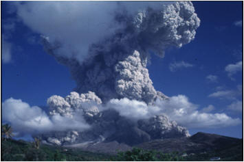
Pyroclastic flows and surges
Pyroclastic flows are high-density, fast
moving, mixtures of hot, dry rock fragments, violently expanding hot gases that
rapidly move away from the vent (or lava dome) from which they were generated.
They are usually associated with acidic, andesitic to rhyolitic volcanoes. Most
pyroclastic flows consist of two parts; a basal flow of coarse rock fragments
that move along the ground surface and a turbulent cloud of ash (the surge) that
rises above the basal flow. Ash may subsequently fall from this cloud, to be
deposited by the prevailing wind on the down wind (lee) side of the volcano.
Pyroclastic flows travel at high velocities, tens to hundreds to metres per
second and high temperatures, between 300 to 800oC. They may be
generated by range of mechanisms. These include an explosive eruption and the
subsequent collapse of an eruption column or the gravitational collapse of a
lava dome. The latter are known as ‘block and ash flows’ and tend to be smaller
is size than the voluminous, pumice-rich ‘ignimbrites’ that accompany eruption
column collapses.
Rock fragments in pyroclastic flows vary from
ash to boulders in size and typically travel at speeds of at least 80 km h-1.
They also may be heavily loaded with debris which they have obliterated form
their paths, such as tree stumps. The direction of pyroclastic flows tend to be
controlled largely by the topography and in particular deeply incised stream and
river channels that may have been eroded into the flanks of the volcano. The
deposits of loose ash and volcanic rock debris vary from 1 to more than 200 m in
thickness.
Pyroclastic flows and surges are one of the
most life-threatening of all volcanogenic hazards. They are capable of complete
total structural damage and destruction to life and land. Substantial
pyroclastic flows may also give way to secondary, explosively driven secondary
flows, or they may become remobilised to form destructive debris flows. On the
margins of pyroclastic flows animals and people may be killed or serious injured
as a result of burns and inhalations that accompanies the hot ash and gases
forming the surge cloud.

Development of a
pyroclastic flow from a lava dome collapse. (Image Source:
volcanoes.usgs.gov )
Lahars
The term lahar is of Indonesian origin used
to describe flows involving mixtures of water and debris, or sediment-laden
flow, in and around volcanoes (Verstappen 1992; Hungr et al. 1987;
Macedonio & Pareschi 1992; Caruso & Pareschi 1993). This is a generic term,
referring to an event, rather than a deposit. Lahars have also referred to as;
hyperconcentrated flows, volcanogenic debris flows, mudflows, debris flows,
cohesive and non-cohesive flows; they may be hot or cold (United Nations 1996).
This however, implies specific flow behaviour, characteristics and composition
(Barclay et al. 2004; Mathews et al. 2002). Lahars occur during
and after volcanic eruptions and their properties depend largely on whether they
are hot or cold. Cold lahars, often called debris flows, may be triggered by
rainstorms, earthquakes, melting snow or landslides. Hot lahars usually also
release large volumes of gases and are generally more destructive than the cold
lahars. Some lahars are generated by the secondary failure of fresh pyroclastic
flow deposits, which may be still incandescent. These may flow as boiling rivers
of mud and pyroclastic debris, at temperatures of several hundreds of degrees
and for distances of over 100 km. Lahars vary considerably in size and speed.
Small lahars may be less than a few metres wide and several tens of centimetres
deep and may flow for a few metres per second. By comparison, larger lahars can
be hundred of metres wide, tens of metres deep and can flow several tens of
metres per second. Lahars, when they are flowing, appear to have the consistency
of wet concrete that transports rock debris ranging in size from clay to
boulders at least 10 m in diameter. Following a volcanic eruption, the erosion
of large quantities of loose debris can led to flooding and extremely high rates
of sedimentation on the middle and lower flanks of the volcano. Post eruption
lahars, triggered by intense, prolonged rainfall and hurricanes, are able to
bury towns, infrastructure and agricultural land. Upstream areas of rivers
choked with volcanic debris and lahar deposits often become flooded. If the
large becomes large enough it may eventually breach the blockage or break
through causing a sudden release of huge volumes of water and sediments and
threatening towns and villages located down-stream.
When a lahar is first generated it is
accompanied by a characteristic sound that resembles ‘leaves rustling in a wind
storm’. The first pulse often has destructive properties that erode the rock
mass and vegetation from the floor and side walls of the channel in which they
are flowing. This addition debris incorporated into the lahar may result in the
lahar growing considerably in magnitude. With increasing distance form the
volcano, the velocity of the lahar becomes reduced, the ability to carry larger
rock debris is therefore constrained and the heavy loaded material is deposited
first. Eventually lahars cease flowing completely resulting in the deposition of
mud across flood plains, large tracts of land, or on the floor of the sea or a
lake.
One lahar deposit may lie above another,
separated by periods of time varying from hours to several hundreds of thousands
of years. Lahars are often generated as a series of discrete pulses, or waves.
When they reach a break in slope, or a standing body of water (like a lake or
the sea) their velocity dramatically reduces and they may spread out to form
fans. Lahar deposist can impede drainage channels, block rivers, silt up
estuaries and extends the land mass in a seawards direction by the generation of
a delta.
The discharge of huge volumes of water from
crater lakes may also generate lahars.
For example, in 1919 approximately 3.85 x10⁷m3
of water was expelled from the crater of Mont Kelut, in Indonesia. This
subsequent mixed with pyroclastic material to form lahars that killed over 5100
people and destroyed 9000 homes (Suryo and Clarke 1985).
The generation and mechanisms of lahars are
complex and appear to be generated in a series of discrete individual pulses, or
surges, controlled by sediment and water availability, gradient and channel
confinement and morphology (Hodgson & Manville 1999; Lavigne & Thouret 2002;
Lavigne & Suwa 2004; (Donnelly 2007a, 2007b, Donnelly et al. 2006).
Primary lahars are those generated as a direct consequence of volcanic activity,
otherwise, when they are associated with other causes, such as heavy prolonged
rainstorm or hurricanes, they may be known as secondary lahars.
Unlike lava flows, lahars can not be out run
by people. Lahars that travel several tens of kilometres along river valleys and
spread across flood plains often result loss of lives, the partial or complete
burial of villages and towns that may become buried beneath a blanket of mud.
The aftermath of a lahar may cause serious economic and environmental damage.
The direct impact of a the turbulent flows that accompany the front of a lahar
may shear off buildings at their foundation level, destroy bridges, choke
rivers, block roads and railways, trap and drowned people and cause forests to
be felled. The affects on people are magnified if the lahars deposist are deep,
soft and hot.
Volcanic gases (volatiles)
When magma is erupted it separates into
incandescent lava and a gaseous phase. Steam accounts for 90% of the gases
emitted during a volcanic eruption. In fact, volcanic gases are thought to be
responsible for the origin of water on Earth, in the atmosphere, on land and in
the oceans. The main other gasses which are erupted include; carbon dioxide,
carbon monoxide, sulphur dioxide, sulphur trioxide, hydrogen sulphide, hydrogen
chloride, hydrogen fluoride. Secondary gases emitted may include; methane,
ammonia, nitrogen, hydrogen thiocyanate, carbonyl sulphide, silicon
tetra-fluoride, ferric chloride, aluminium chloride, ammonium chloride and
argon. The composition of gases emitted from a volcano depends on the initial
composition of the magma.
When a magma chamber is situated at a
relatively shallow depth, say 7 to 14km, and the temperatures and pressures are
relatively low, water tends to move to the top of the magma. This may help to
explain the often violent, explosive start to the onset of a volcanic eruption.
The resultant gas column may carry pumice and steam several thousands of metres
into the air. At high pressures (when the magma is much deeper in the Earth’s
crust), the gas is held in solution and the explosiveness of the eruptions will
depend upon the rate which the gas is released from solution as the magma
ascends to shallower crustal depths. Lavas may frequent contain vesicles,
representing gas that has remained in the lava. The rapid escape of this gas may
lead to surface frothing of lava and splattering.
Fumaroles are commonly found near dormant
volcanoes (for example the Salfatars to the north of Naples, Italy) and near to
the summit of active volcanoes. Superheated steam may be observed to violently
issue from fissures. These are composed mainly of steam with smaller proportions
of carbon dioxide and hydrogen sulphide. Oxygen in the atmosphere may react with
the hydrogen sulphide to form free water and sulphuric acid. Where steam escapes
through saturated ash boiling mud pits may be formed.
Hot springs are common where active and
extinct volcanoes occur. They originate when hot volatiles are driven off during
the late stages of a magma chamber as it crystallises and solidifies. Hot
springs contain carbon dioxide, hydrogen sulphide, dissolved salts, and when hot
enough, dissolved silica. On cooling and where groundwater flows occur they may
deposit sinter terraces or travertine. Geysers are hot springs that violent emit
water explosively, often at regular intervals, up to about 100m in the air. The
time between each eruption is minutes or days, and this varies over time.
Volcanic gases are harmful to life. The gases
that present the greatest hazard to life are sulphur dioxide, carbon dioxide and
hydrogen fluoride. Volcanic gases which contain fluorine, chlorine and sulphur
(sulphur dioxide and hydrogen sulphide) can be toxic, which can also be emitted
from hot springs and fumaroles. Fluorine can also poison live stock grazing on
ash-coated vegetation and may also contaminate domestic water supplies.
Carbon dioxide is a colourless, odourless gas
and does not pose a direct hazard to life as it normally occurs in low
concentrations. However, carbon dioxide may become concentrated to levels that
are hazardous to people and animals. Since carbon dioxide is denser than air it
can sink down the flanks of the volcano, flow into confined spaces, voids and
low lying areas, suffocating animals and humans where concentrations of carbon
dioxide reach 30% in air.
Sulphur dioxide is a colourless gas with a
pungent odour that irritates skin, tissues, membranes of the eyes, nose and
throat. It affects the upper respiratory tract and bronchi. According to the
World Health Organisation a person should not be exposed to no greater than 0.5 ppm in a 24 hour period. At concentrations of 6-12 ppm this will cause
irritation of the throat and nose and at 20 ppm can cause eye irritation.
Chlorine is emitted from volcanoes in the
form of hydrochloric acid. Exposure to this gas can irritate the membranes of
the eyes and respiratory tract. Concentrations over 35 ppm cause irritation of
the throat and >100 ppm result in pulmonary edema and laryngeal spasm.
Hydrochloric acid also may generate acid rain on the down-wind flank of
volcanoes. It is extremely soluble in condensing water to produce strong ‘acid’.
Fluorine, a pale yellow gas, adheres ash
particles, pollutes streams and surface water bodies and covers vegetation.
Exposure to this gas can cause conjunctivitis, skin irritations, bone
degeneration, mottling of teeth and can cause fluorosis and death following
prolonged exposure. Animals that eat vegetation covered with fluorine-ash are
poisoned. Like hydrochloric acid it also caused acid rain on the down-wind side
of volcanoes.
The cataclysmic eruption of Mount Pinatubo,
Phillipines, on 15 June 1991 injected 17 million tonnes of sulphur dioxide gas
into the stratosphere, where it subsequently combined with water vapour to form
an aerosol (fine mist) of sulphuric acid. Such aerosols can reflect solar
radiation and lower the Earth’s average surface temperature for extended periods
of time, by several degrees centigrade. In the case of Mount Pinatubo, this
resulted in a 0.6oC cooling of the Earth’s surface in the northern
hemisphere. Such aerosols can also contribute to the destruction of ozone in the
upper atmosphere. Approximately 130-230 million tonnes of carbon dioxide is
released annually from volcanoes into the atmosphere (Gerlach 1999, 1991). By
comparison, the emissions of carbon dioxide by human activity, caused for
example by the burning of fossil fuels, gas flaring and cement production, is
about 30 billion tonnes per year (Marland et al. 2006, Gerlach et al.
2002).
Emissions of Carbon dioxide may occur in the
absence of volcanic eruptions. Such events around crater lakes in Manoum in 1984
and Nyos in 1986, Cameroon, resulted in at least 1700 deaths. Carbon dioxide
emissions were caused at Lake Nyos by the periodic convectional stirring of
water layers in the lake which had different densities (Kling et al.
1987; Baxter and Kapila 1989; Walker et al. 1992).
The long term degassing of some volcanoes can
cause damage to agricultural land and respiratory problems in the populations,
as is occurring at Poas volcano in Costa Rica. Volcanic gases are also likely to
be contributory factors that have a cooling effect on global climate, caused by
gases such as sulphur dioxide in the stratosphere absorbing incoming solar
radiation.
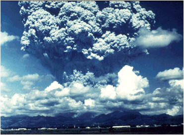
Tephra, pyroclasts and ash
Tephra is a general term for fragments of
volcanic rocks and lava, regardless of size, that are blasted into the air by
explosions or carried upwards by hot gasses in an eruption columns or lava
fountains. These may range from less than 2mm to over 1 m in diameter.
‘Pyroclastic’ is a collective term applied to
material that has been fragmented by explosive volcanic activity. Pyroclasts may
consist of lava fragments exploded during an eruption and fragments of country
rock that have been blown from the central neck of a volcano. The size of
pyroclasts is highly variable depending on the amount of gas coming out of
solution, the violence of the volcanic activity and the height of the eruption
column. Blocks over 1 tonne in with may be ejected into the air and ash so fine
may take years to fall back to the Earth’s surface (or into the sea).
Volcanic bombs are larger pyroclasts
consisting of molten lava or wall rock fragments. These tend to fall within a
few kilometres radius of the eruption. They may destroy structures on which they
fall, ignite crops, forests and homes. Lapilli is pyroclastic material that has
a diameter ranging from 10 to 50 mm. Scoria or cinder is irregular shaped
material of lapilli size. These are vesicular, glassy and can be ejected within
a radius of several kilometres from a volcano.
Volcanic ash is the finest pyroclastic
material. Ash consists of tiny fragments of lava, less than 2 millimetres in
diameter, or rock blasted into the air by volcanic explosions. Ash is hard,
abrasive, corrosive, conducts electricity when wet and is insoluble in water.
More ash is produced from acidic rather than basaltic volcanoes because the
former is more viscous which prevents the gas from escaping. Larger diameter,
heavier ash particles fall back closer to the eruptive centre whereas finer
particles are blown away and may travel hundreds to thousands of kilometres (for
example during the eruption on Mount St. Helens in 1980).
Ash deposits show vertical and horizontal
variations and their thicknesses generally decrease exponentially with greater
distances from a volcano. The resulting ash deposist will depend on the particle
size of the ejecta, height of eruption column, rate and duration of eruption and
prevailing wind conditions.
As the ash particles becomes compacted, by
subsequent ash falls, after they have been deposited on the ground, their bulk
density increases by as much as 50% within a few weeks of an eruption and the
thickness of the ash deposits decrease over time. The density of ash particles
varies from approximately 700-1200 kg m-3 for pumice, 2700-3300 kg m-3
for glass shards, 2600-3200 kg m-3 for lithic (crystals and rock
fragments) particles (Shipley and Sarna-Wojcicki 1982). However, actual bulk
densities will vary depending on the degree of saturation of the ash, grain
size, composition and particle shape (more spherical, well rounded grains will
result in a lower porosity and higher bulk density). For example, 10mm of ash
may add 19 kg weight to each square metre of roof.
Ash is abrasive due to the hardness of the
mineral forming particles and their shape being made mainly of sharp, broken
high silica minerals. The minerals within volcanic ash are derived from magma,
where they crystallised before the eruption. Volcanic glass shards represent
fragments of the molten magma that cooled and solidified during an eruption.
They are the remnants of small gas bubbles that grew in size during the ascent
of the magma towards the Earth’s surface. They were subsequently erupted and the
rapidly expanding gas disintegrated the bubbles and surrounding glass into
shards of various shapes and sizes. Violent eruptions that accompany
phreatomagmatic eruptions generate particularly angular shaped shards caused by
the violent interaction between water and magma.
Volcanic ash may be spread over large areas
by winds and is can turn daylight into complete darkness. Accompanied by rain
and lightening, it can cause power outages, hinder communications and disorient
people caught up in the ash plume. Ash falls can cover and bury houses, farmland
and infrastructure, cause roofs to collapse, destroy crops, block streams and
rivers.
Long term exposure to volcanic ash can cause
respiratory aliments in people and can lead to silicosis. Ash deposits also may
destroy vegetation, which in turn can promote increased rates of surface run-off
following rainstorms, increase the availability of loose debris to aid erosion,
result in the persistence of air borne ash, increase sediment and debris supply
into rivers. In some cases the increased sediment supply combined with running
water may severely damage infrastructure, cause the impounding of rivers and
flood hazards.
When ash falls in areas which are paved, or
there is little vegetation, human activities, moving vehicles and agricultural
activities may cause the ash to become mobile. Wet ash has more cohesive
properties and will reduce the reworking and disturbance of the fallen ash
deposits. The upper surface layers of the ash may also be impermeable caused by
the precipitation of insoluble salts by evaporation.
Extremely fine ash particles may be ejected
into the stratosphere and circle the Earth for months or years. This can
scatter, absorb and reflect solar radiation and may obscure the sun for several
hours or day. This may potentially also lead to small reductions in average
temperatures.
Airborne ash can obscure sunlight and cause
temporary darkness or reduced visibility. Wet ash is hazardous when wet,
especially to roads, highways and airport runways that may become impassable.
Car and jet engines may stall from ash-clogged air filters and moving engine
parts (including breaks, transmission and bearings) may be damaged by the
abrasive properties of ash. Since the early 1980s at least 80 civil aircraft
have been damaged by flying into ash laden eruption clouds, at least two of
these events in Alaska (1989-90) and Indonesia (1982) almost resulted in
crashes. The 14 km high ash cloud generated by the 17 September 1986 eruption of
the Soufriere Hills Volcano in Montserrat, caused engine and windscreen damage
to an Air Canada jet.
The Tambora eruption in 1815 caused the
failure of crops due to widespread ash deposits, resulting in 90,000 deaths due
to famine. Widespread crop failure and starvation caused by ash falls also
accompanied the 1793 Laki eruption, in Iceland, which resulted in the deaths of
25% of the population and 200,000 livestock (Thordson and Self 1993). Most of
the 'recent’ volcanic eruptions have also resulted in significant ash hazards
including for example Mount St Helens, USA, 1980; El Chicon, Mexico, 1982;
Pinatubo, Phillipines, 1991; Cerro Hidson, Chile 1991; Rabaul, Paupa New Ginea,
1994, Souffiere Hills, Volcano, Montserrat, West Indies 1996-ongoing.
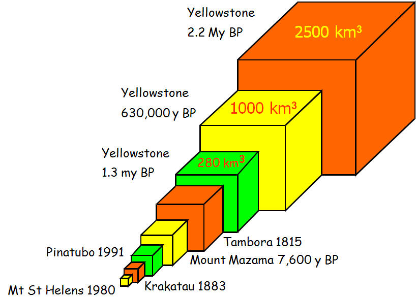
Some comparative
volumes of ejecta from volcanic eruptions. (Image Source: Prof.
Bill McGuire, University College London)
Explosions
Explosive volcanoes rather than effusive
volcanoes have the potential to create widespread structural damage and deaths.
Explosions vary enormously in scale, form localised explosions that affect only
local communities who live on the flanks of a volcano, mainly by the generation
of pyroclasts and bombs, to entire regions. Explosive eruptions are
characterised by the Volcano Explosivity Index (VEI) (Newhall and Self 1982).
The VEI is a logarithmic scale from 0 to 8
and is based on the amount of material ejected during an eruption and the size
of the eruption column. VEI events which measure 1 to 3 are localised, while the
effects of a 4 to 5 eruption can disrupt life on a regional scale. VEI 6 and
greater events can affect the population of the Earth through their impact on
climatic change. For example, the May 1980 eruption of Mount St Helens in the
USA had a VEI of 5 and the 1991 eruption of Pinatubo in the Phillipines had a
VEI of 6. Only once every thousand years does a VEI 7 event occur, the last
being the 1815 eruption of Tambora in Indonesia. There is no record of a VEI 8
event during the Holocene. The last being the ‘super-eruption’ of Toba, in
Sumatra, Indonesia, a cataclysmic event that occurred approximately 74, 000
years BP (Rampino and Self 1992). This event may have triggered global climatic
changes and accelerated an already cooling planet into an ice-age. Modern
civilisations has yet to face a VEI 8 eruption, however, interestingly, the
estimated return period for a VEI 8 is 50,000 years (Simkin and Siebert 1994).
This potentially may reduce the average temperature of the Earth by 3-5oC
(Rampino and Self).
Large explosive eruptions may be preceded and
accompanied by earthquakes and huge emissions of noxious gases, mainly sulphur
dioxide and carbon dioxide, which can cause structural damage and loss of life,
respectively.
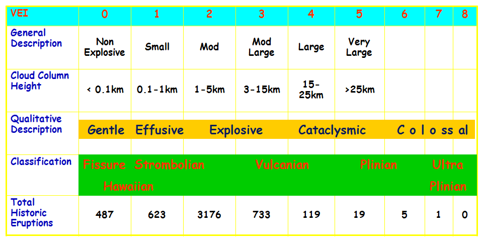
The Volcano Explosivity Index (VEI)
scale.
Volcanogenic landslides (volcanogenic
debris avalanches)
Landslide is the relatively rapid movement of
a mass of rock, earth (soil) or debris (a mixture of rock and earth) down a
slope, under the influence of gravity. Landslides may be classified in several
ways depending upon; mode of failure, initial rupture surface, dominant form of
displacement, behaviour of the rock and/or soil once movement has commenced and
the subsequent deformation of the material (Varnes 1978, 1984; UNESCO 1990,
1993; Dikau et al. 1996; Hutchinson 1988). The type of ‘materials’
displaced during landsliding is recognised by the further division based on the
following:
Soil: fine grained engineering soil
(silt, clay and organic material)
Rock: insitu bedrock
Debris: coarse grained engineering
soil, of sand size or greater and/or an admixture of gravel or boulders,
(rock and soil)
Volcanogenic
landslides (sometimes called volcanogenic debris avalanches) occur when a
sizeable part of a volcanic edifice becomes unstable and slides under gravity
catastrophically. These may be associated with an eruption or occur during a
period of reduced activity. Such landslides may be generated rapidly, over
periods from weeks to months or occur progressively over period of thousands of
years (McGuire 1995, 1996; McGuire and Saunders 1993; Siebert 1984, 1992;
Donnelly 2007a, Donnelly 2007b, Donnelly et al. 2006). On siliceous
volcanoes the gravitational failure of an over-steepened lava dome can lead to
the generation of a volcanogenic landslide that may lead to the generation of a
pyroclastic flow.
Some volcanogenic landslides frequently begin
as a rockslide, which disintegrates during failure, into fragments ranging in
size from small particles to large blocks hundreds of metres in size. Volcano
landslides have been observed to occur ranging in volume form less than 1 km3
to at least 100 km3. Volcano landslides are major destructive events
that have destroy structures and land, cause loss of lives, trigger volcanic
eruptions, lahars and tsunamis. Landslides may travel down-slope and up-slope
for several hundreds of metres. Volcano landslides are triggered by a number of
inter-related factors that may include the following:
Size (height) of the volcano slopes
Deposits of lava and pyroclastic
materials
Magmatic intrusions
Hydrothermal activity
Magmatic and phreatic intrusions
Earthquakes
Intense prolonged rainfall
The displacement of a significant portion of
a volcano, caused by a landslide, can reduce the confining pressure on shallow
magmatic and hydrothermal systems. This can generate explosions and volcanic
eruptions that range from small phreatic (steam) explosions, to magma driven
blasts. Associated affects may include the damming of stream and rivers,
flooding, burying landscapes and the transformation of landslides into lahars.
Historically, the most deadliest volcano
landslides occurred at Mount Rainer volcano, Washington, USA and from Mt
Mayuyama (in 1782), which is located near Unzen Volcano, Japan. The landslide
entered the Ariaka Sea and generated a tsunami that killed 15,000 people (Tsuji
and Hino 1993).
On 18 May 1980 a landslide on Mount St.
Helens, located in the Cascades Range in the Pacific Northwest, USA, had a
volume of 2.5 km3, travelled at a speed of 180-288kmh-1
(50-80ms-1) and surged up, then over a 400 m high ridge, some 5 km
from the volcano. The landslide triggered the most destructive and extensive
volcano in the USA in recent times (Lipman & Mullineaux 1981, Foxworthy and Hill
1982, Tilling 1987). Other notable volcano landslides have occurred at; Otake
Volcano, Japan (1984), Huila Volcano, Colombia (1994) and Casita Volcano,
Nicaragua (1999).
Volcanogenic earthquakes
Volcanogenic earthquakes are a consequence
the movement of magma within the volcanic complex, geothermal and hydrothermal
activity and from surface processes such as the collapse of an andesitic dome,
explosions, rock falls and eruptions. Volcano-seismicity can result in damage to
civil engineered structures and loss of life. These may accompany volcanic
eruptive activity or be induced by the movement of magma beneath a volcano
without eruptive activity.
Seismic monitoring of volcanoes provides
information on earthquakes that accompany the movements of magma, migration of
volcanic gases, movement of hydrothermal groundwater systems, high-frequency
earthquakes that are associated with rock fracturing, low frequency tremors,
explosions and landslides. These earthquakes occur in swarms, less than 10 km
beneath a volcano and are normally less than a magnitude 2 or 3. Volcanogenic
earthquakes generally have lower magnitude than those caused by tectonic
activity, but they may persist for longer, from hours to weeks. Structural
damage is often limited to areas in the vicinity of the volcano, especially
where houses and buildings have been poorly constructed, and rarely affect the
wider regions. For example, volcanogenic earthquakes at Campi Flegrei caldera,
Napoli, Italy from 1982 to 1984 caused severe structural damage and resident
living in the town of Pozzuoli, located near to the epicentre, were evacuated (Barberi
et al 1984).
Volcanogenic fault reactivation and ground fissuring
Aseismic creep may occur along faults located
on the flanks of volcanoes. At Mount Etna, Sicily, these ground movements in the
vicinity of faults that are situated near potentially unstable slopes are
monitored to investigate the landslide and tsunami risks (Lo Guidice and Rasa
1992, Rasa et al. 1996).
Volcanogenic tsunami
Tsunamis may be associated with major
explosive volcanic eruptions. Such events occurred during the eruption of
Krakatoa, in Sumatra, in 1883, which killed 36,000 people who lived along the
coasts of neighbouring islands (Simkin and Fiske 1983). Other notable tsunami
events generated by volcanic eruptions occurred in Hawaii (Moore and Moore 1984)
and Australia (Young and Bryant 1992). Volcano induced tsunamis may potentially
affect and devastate large parts of the Earth from an explosive event of major
volcanogenic landslide entering the ocean. In the latter case, such an event has
been postulated to occur (by some volcanologists) from the partial collapse of
western flank of Cumbre Vieja volcano, on the island of La Palma, the Canary
Islands, which may generate tsunamis that could catastrophically affect the
eastern sea board of the USA.
Index |
Diagnostic Characteristics
|
Geographic Occurrence |
Investigation & Mitigation |
Key Contacts & Expert Advice |
Photo
Gallery |
Essential References &
Further Reading | Definitions &
Glossary |
|